When Amy Barron took the stage at a 2021 internal summit for Duke Energy—one of the largest utilities in the United States—she issued an ambitious call for collaboration.
A 14-year veteran of the company, Barron leads the geographic information system (GIS) team supporting customer delivery in North and South Carolina. On stage, she said the GIS-based smart maps used throughout Duke Energy were just a start. If used strategically, the technology could provide deeper geographic context, known as location intelligence, that would streamline workflows and improve decision-making.
In the audience that day was Jason Haden, manager of Duke Energy’s Enterprise Security Command Center, which monitors the utility’s facilities 24/7/365. Haden had been thinking about ways to bridge resources among other security operations at Duke Energy, including cybersecurity, compliance, and threat intelligence.
Barron’s speech underscored that geography could be the common ground for those partnerships, Haden says. “Because of mergers over the years, there were many things about security elements and security features that were disparate across our seven-state footprint. The question was: How do we unify that?” Haden says. “After hearing Amy talk about the unification of GIS, I was like, ‘We’ve got to do this.’”
Collaboration Built on the Power of Location
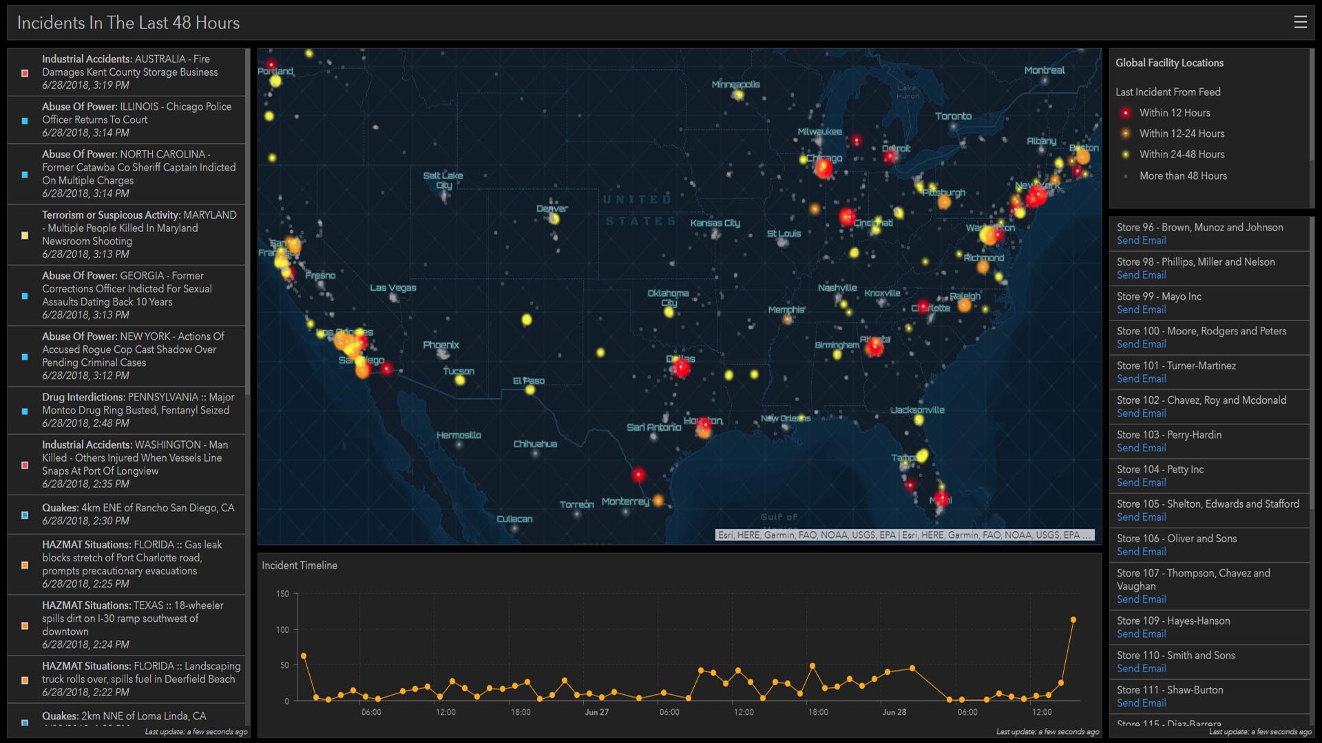
It wasn’t the first time Duke Energy’s GIS team had collaborated with the company’s physical security team. Haden had previously worked with senior GIS analyst Garrett McKinney and lead intelligence analyst Forrest Kelley to create a GIS-powered Threat Awareness Portal. The GIS dashboard reveals crime data, a live feed of location-tagged incidents, and other key data points. The Threat Awareness Portal is a hub for information that each security division can tailor to its needs.
But the unifying potential of location intelligence went further still. Once Haden, McKinney, and Kelley saw how useful the dashboard’s insights were to their teams, they quickly realized that business units across the company could benefit from them as well, especially Duke Energy’s 12,000 field employees.
“With a territory as large as ours, you can’t see everything, you can’t know everything,” Barron says. “But you can start by having people share data and awareness of things that they’re seeing and doing.”
The security team partnered with McKinney and other GIS colleagues to scale the Threat Awareness Portal to every business unit in the company. The data-driven platform now gives Duke Energy employees a new level of situational awareness to make smart calls about safety.
It’s a process that owes much to the catalyzing influence of Barron, who helped colleagues collaborate through location intelligence.

We’ve taken a chance on trying something new and we had leadership support and it’s been successful. It'll continue to be successful because we continue to show the value of what GIS can do.
Security Insights Revealed by GIS
GIS is integral to Duke Energy’s business, thanks in part to the efforts of Barron, who helps colleagues see its relevance across multiple departments—often through the GIS Day activities she sponsors. Company leaders use location technology to monitor transmission, distribution, and gas assets, as well as security.
As one of the nation’s largest energy holding companies, Duke Energy understands its responsibility to protect its assets and information, and has a multi-layered security strategy focused on preventing cyber events and threats to critical infrastructure. The company’s electric utilities serve more than 8.2 million customers across six states, and its natural gas unit serves 1.6 million customers across five states. While tending to this sprawling network of assets, lineworkers and technicians occasionally find themselves in the vicinity of ongoing incidents that are unrelated to Duke Energy’s work.
While these incidents aren’t common, Kelley says, any business that regularly interacts with the public can encounter these scenarios occasionally. That’s why Duke Energy—which sees safety as its top priority—wanted to give teammates in the field as much visibility into their surroundings as possible.
So Haden and Kelley, with help from McKinney, expanded the Threat Awareness Portal to give workers better awareness of their surroundings when in the field. When employees log onto the portal, they see a map displaying counties color-coded for historical crime data, with darker hues signaling higher annual rates of personal crime. Orange dots indicate lower-level threats, while red dots signal a more serious hazard.
For additional context, an AI-powered app called Dataminr scans social media accounts and other sources of public data to provide real-time information on emerging risks, which appear on the map as blue dots. A repairperson leaving the depot can see at a glance whether an altercation occurred that morning on the block where they’ve been assigned.
Duke Energy’s security leaders felt smart maps were the most effective way to communicate the data and equip employees.
“We’ve got crime data down to the city block,” Kelley says. “You can really visualize, ‘I’m here right now, and I’m going here. Is there anything between here and there that could impact me?’”
A Unified Security Platform
One of the first steps in creating the Threat Awareness Portal was ensuring that all the company’s assets—from substations to thousands of miles of power lines—were accurately mapped. This can be a challenge for organizations that have expanded through acquisitions, as data can become siloed by organizational barriers.
GIS tends to break through those barriers by serving as the authoritative source for location data. Duke Energy’s maps allow security professionals to gauge whether reports of social unrest, crime, or even geopolitical risks occur in proximity to any of the utility’s infrastructure.
“Anytime we have a developing event, the first thing we do is jump on the GIS platform and pull up our layers,” Kelley says.
With this information in hand, the security teams can issue status updates to company leaders, local law enforcement, or even federal officials, depending on the level of severity.
“We’ve got such a large footprint with thousands of assets that vary in criticality,” Kelley says. “Getting plugged into GIS and getting the [map] layers that have our generation, transmission, distribution assets, and all of our gas assets has been huge for us.”

The biggest thing that I learned was to engage—to have the GIS analyst involved every step of the way. . . . They're not the security professionals, but GIS has a lot of data available to them that can be very valuable.
How Location Intelligence Gives Leaders “One Big Picture”
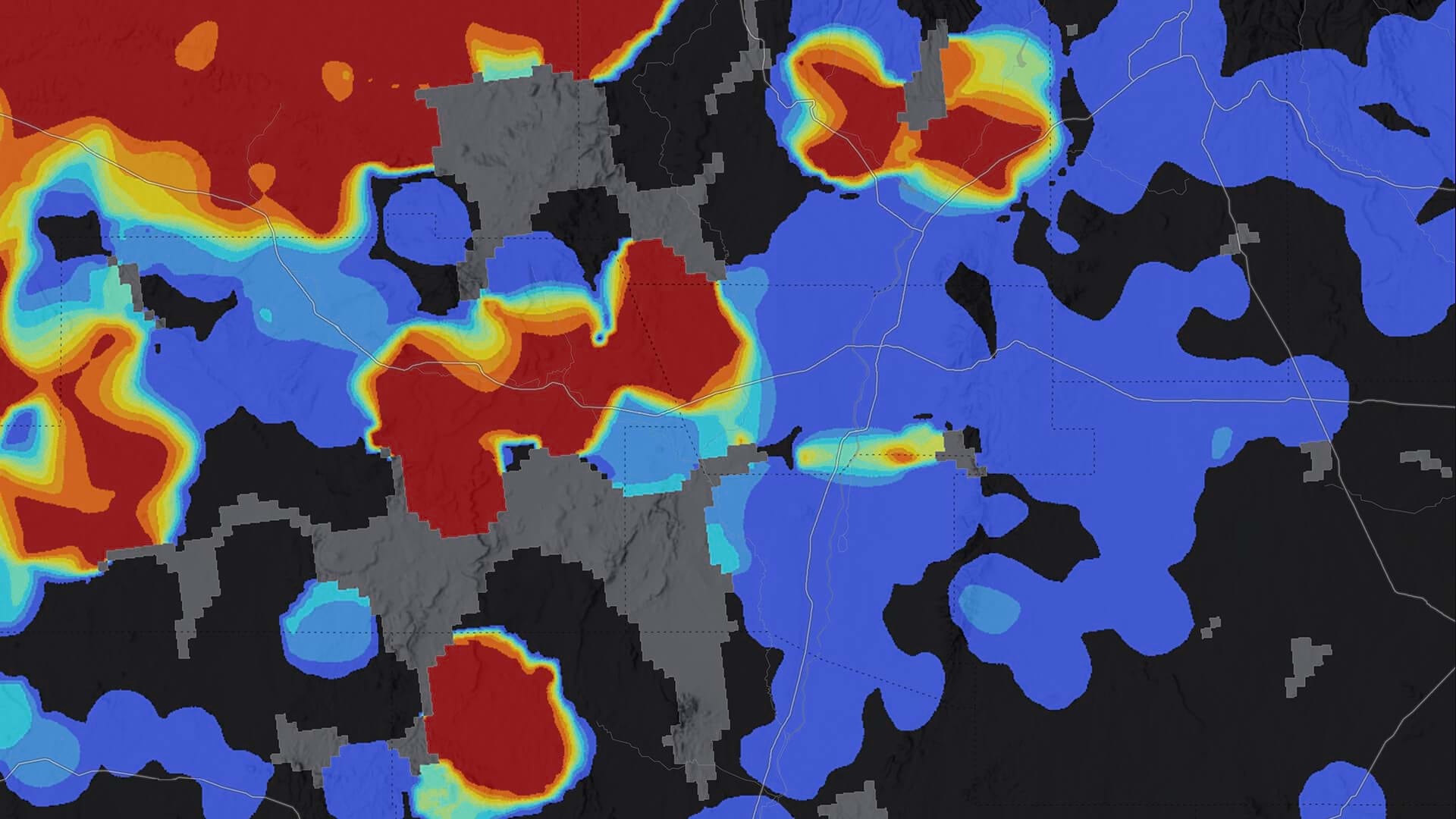
The Threat Awareness Portal also enables Kelley and his team to detect location-based patterns in security threats and shore up defenses accordingly. For instance, location intelligence could help them trace reports of activities by a violent extremist group, which could lead Duke Energy to increase security near a particular asset or area.
With McKinney’s help, Kelley used location insights to build a security risk map that informs executive decisions. This smart map assigns a risk score to every county where Duke Energy operates by analyzing annual crime rates, employee presence, security assets and personnel, and the location of critical facilities.
“Instead of having to flip from one app to another to see the different pieces, now it’s all in one big picture,” McKinney says.
The Future of Corporate Security
Duke Energy’s safety culture thrives on continuous improvement, and the team’s next step is to make the Threat Awareness Portal available on mobile devices so workers can check threat assessments from the field. Duke Energy’s trucks are also telemetry-enabled, raising the possibility of strategic geofencing. That GIS capability would automatically send an alert to an employee’s phone when they drive into a high-risk area or a neighborhood where a crime has occurred.
Incidents in the field are rare, but when they occur, the location intelligence in Duke Energy’s security portal gives employees the situational awareness they need to respond.
“I think it’s one of the biggest achievements we will have made in the five years since I’ve been here,” Haden says of the collaboration that brought the security app to life. “It’s a tangible way that the information we gather and push out is helping the entire Duke Energy company.”